
The National Hurricane Center (NHC) has the responsibility of announcing and categorizing all hurricane and cyclone activity in and around North America. This includes the expected track of the storm, the size, rainfall, storm surges and other aspects that go along with Atlantic and Pacific storm formations. These storms are forecasted using specific models for accuracy and includes the use of satellites, aircrafts, ships, radar and buoys to make the most accurate predictions. The use of satellite specifically is utilized while the storm is in open water which allows for measurements and estimated characteristics of the storm. This also allows the NHC to predict where landfall will occur and at what intensity. These new generation of weather satellites are equipped with sensors and instruments that provide real-time monitoring of weather from space.
The Atlantic and Pacific Geostationary (GOES) satellites continuously study hurricanes from formation to dissipation and according to Dan Lindsey, a satellite scientist, he admits that the new GOES-16 series of satellites go beyond the previous models and provide “a significant improvement over the imager aboard the legacy GOES series.” He goes on to say that “Now, forecasters are seeing more details, even smaller-scale cloud features associated with tropical cyclones.”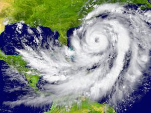
Once a hurricane becomes a risk to land, the Air Force and storm tracker aircraft including drones, using high quality custom lenses, and land stations become an indispensable asset for determining overall storm conditions and land risk. One specific unmanned aircraft, NASA’s Global Hawk is utilized as an experimental aircraft to determine exact coordinates of the storm as well as other vital information and insights. As the storm gets closer to land, within about 300 miles, land-based radars take the place of aircraft to provide wind speed and precipitation information. Weather balloons and the Automated Surface Observations Stations (ASOSs) also help to gather additional measurements and statistics.
Once all data is gathered, it is analyzed for errors and then compared to other character models which is used for providing official storm warnings and instructions for the public. Because many storms can change course and intensity quickly, it is important that the NHC utilize multiple models and compare based on current environmental aspects and other present-day data.
In total, the NHC is comprised of other departments such as the Tropical Analysis and Forecast Branch (TAFB), Hurricane Specialists Unit (HSU), and Hurricane Liaison Team (HLT). Specifically, the TAFB is in charge of offering forecasts 24 hours a day, 365 days a year and monitors over 14 million nautical miles.
The HSU is tasked with monitoring the Atlantic and Pacific basins and then produces advisories for the public including news content and plot maps outlining the storms track. These advisories are updated every 6 hours to keep the public aware of current conditions and tracking patterns. When land-based radar is utilized, the HSU may periodically issue updates in 2-hour windows when data is available. They also offer briefings to emergency managers around the country in order for local emergency managers to make plans regarding their geographical location and local safety protocol.
Finally, the HLT is a Federal Emergency Management Agency (FEMA) which is comprised of specially trained forecasters. They work as an intermediary between the National Weather Service (NWS) and national and local emergency managers dealing with preparing for storms in the days and hours before a storm makes landfall or begins to impact local areas. Ultimately, the local, state and city officials make final evacuation notices based on information provided by the NHC. Consistency between all these branches of the NHC is pertinent to making the best information available for the public via television, radio, the internet and other forms of media that may be utilized for warnings and evacuation notices. The end goal is to predict these storms using as much information, technology, previous models and current weather conditions available to keep the public aware and safe.